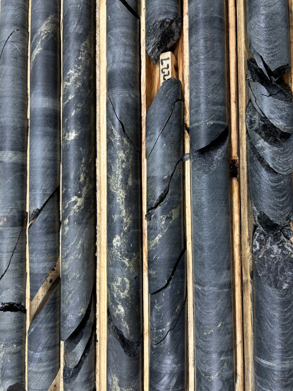
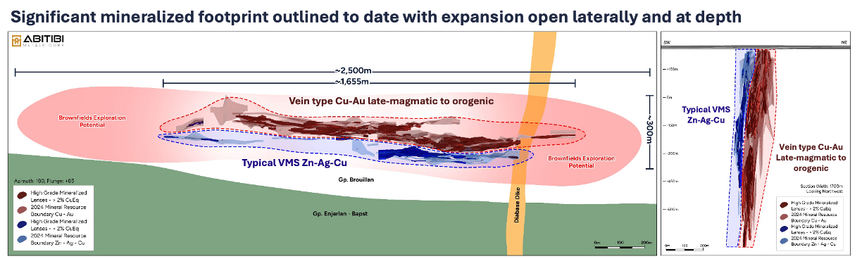
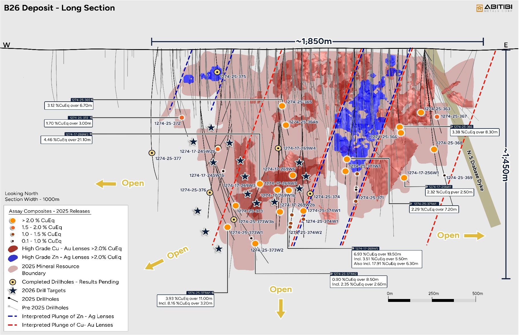
B26 Deposit

Overview

The property is located 5 km south of the Selbaie mine and about 90 km due west of Matagami. It is accessed by a 7-km gravel road that runs southward from kilometre 98.5 on forestry road 810 (gravel) that links the Selbaie mine to the former municipality of Joutel. A network of forestry trails provides access to the drill sites on the deposit. The nearest mining infrastructure is Hecla Mining’s Casa Berardi mine, about 60 km away. The town of Matagami, a 130-km drive from the property, has a skilled workforce and is home to the Glencore mining complex. The infrastructure of the former Selbaie mine has been dismantled, but the power line is still in operation near highway 810.

In 1997, SOQUEM drilled discovery hole B26-03, which intercepted 1.87 g/t Au and 2.89% Cu over 11.3 metres. Since that time, the project has been systematically explored by SOQUEM by drilling 254 holes over 115,311 meters, which was included in their 2018 resource update.

Key Facts

2018 Historical Resource Estimate

Indicated: 6.97 Mt at 2.94% Cu Eq (1.32% Cu, 1.80% Zn, 0.60 g/t Au and 43 g/t Ag) & Inferred: 4.41 Mt at 2.97% Cu Eq (2.03% Cu, 0.22% Zn, 1.07 g/t Au and 9 g/t Ag) 

Location

90 km west of Mattagami and 100 km north of La Sarre, near the former Selbaie Mine.

Ownership

7-Year Option to earn 80% from SOQUEM Inc. (9.9% Equity, $14.5M Work Commitment & $400K Cash)

Size

Covers approximately 3,327 hectares

2018 Historical Resource Estimate

Historical Estimated Resources in the B26 Deposit
Zone Tonnage (t) Classification Cu (%) Zn (%) Au (g/t) Ag (g/t) CuEq (%) ZnEq (%)
Feeder Cu 651,000 Indicated In-pit 1.82 0.04 1.10 6 2.66 NC
14,000 Inferred In-pit 1.33 0.01 0.19 2 1.49 NC
3,713,000 Indicated Underground 2.01 0.10 0.87 7 2.74 NC
4,232,000 Inferred Underground 2.10 0.04 1.03 7 2.91 NC
Horizon Zn 160,000 Indicated In-pit 0.06 2.04 0.03 120 2.10* 4.78
2,244,000 Indicated Underground 0.24 4.98 0.09 99 3.42* 7.78
120,000 Inferred Underground 0.14 4.80 2.93 66 4.93* 11.20
Remob Ag-Zn 203,000 Indicated Underground 0.01 3.02 0.07 138 2.68* 6.09
40,000 Inferred Underground 0.01 4.85 0.10 137 3.49* 7.94
TOTAL 811,000 Indicated In-pit 1.48 0.43 0.89 28 2.55 NC
14,000 Inferred In-pit 1.33 0.01 0.19 2 1.49 NC
6,160,000 Indicated Underground 1.30 1.98 0.56 45 2.99 NC
4,392,000 Inferred Underground 2.03 0.22 1.08 9 2.97 NC
6,972,000 Indicated Total 1.32 1.80 0.60 43 2.94 NC
4,406,000 Inferred Total 2.03 0.22 1.07 9 2.97 NC

*: The copper equivalent values are presented for comparison purposes. These zones are rich in Zn and Ag but are generally poor in Cu.

  1. The cut-off grade used in the pit is an in-situ value of 36.70 $/t (equivalent to 0.67 % Cu or 1.52 % Zn).
  2. The cut-off grade used underground is an in-situ value of 100 $/t (equivalent to 1.82 % Cu or 4.13 % Zn).
  3. The mineral resources were estimated in compliance with Canadian Institute of Mining, Metallurgy and Petroleum standards. These mineral resources were reported in accordance with the NI 43-101 standards.
  4. Mineral resources do not constitute mineral reserves because they have not demonstrated economic viability.
  5. Inferred resources are exclusive of indicated resources.
  6. The effective date of these mineral resources is January 31, 2018.
  7. The resources are estimated with a cut-off on the combined value of a tonne of resource.
  8. The in-situ value of the resources as well as the Cu and Zn equivalents are calculated with 100 % recovery and prices of Cu: 5,500 $/t, Zn: 2,420 $/t, Au: 1,200 $/oz and Ag: 16 $/oz.
  9. All resources are presented in-situ and undiluted.
  10. NC signifies “not calculated”.
  11. A qualified person has not done sufficient work to classify the historical estimate as current mineral resources or mineral reserves. The issuer is not treating the historical estimate as current mineral resources or mineral reserves.
  12. A link to the full resource announcement can be found here.

Geology & Historical Results

The B26 mineralization is composed of a stacking of massive polymetallic and semi-massive polymetallic sulfides lenses extending over a kilometric strike length within a  strongly dipping basin filled by felsic volcanism products. Sulfide-rich mineralization is mostly hosted in rhyolite and associated tuffs. Two main types of mineralization characterize the B26 Deposit. The northern part of the mineralized system is characterized by chalcopyrite veins and veinlets hosted in sericitized and chloritized rhyolite. The southern portion of the system contains mostly disseminated to massive sphalerite, pyrite and galena mineralization, hosted in a dome of massive rhyolite. The zones are stacked in a sub-parallel pattern, oriented generally east-west, and dip 87° to the south.  

B26 Deposit - Summary of Selected Historical Drill Results

Summary of Selected Historical Drill Results
Drill Hole From (m) To (m) Length (m) Cu Eq Cu (%) Gold (g/t) Zn (%) Ag (g/t)
1274-13-117 269.5 359 89.5 2.32 1.95 0.46 0.08 5.47
1274-16-224 113.4 161.5 48.7 3.05 2.66 0.52 0.03 5.75
1274-16-238 583.8 628 44.2 2.55 0.07 0.05 3.45 158.33
1274-14-152 71.8 83.3 11.5 8.95 3.8 7.72 0.03 10.18
1274-14-174 482.5 532 49.5 1.90 1.63 0.25 0.14 6.94
1274-14-208 218 230 12 7.2 5.40 2.62 0.03 8.86

Notes:

  1. The intercepts above are not necessarily representative of the true width of mineralization.

2. Copper Equivalent values calculated using metal prices of $4.00/lb Cu, $1.50/lb Zn, $20.00/ounce Ag and $1,800/ounce Au. Metal recoveries of 100% are applied in the copper equivalent calculation.

3D Model and Section

Project News

Abitibi Metals Drills 44.5 Metres At 2.82% CuEq in Central Drilling At The B26 Polymetallic

Abitibi Metals Drills 19.75 Metres At 1.35% CuEq In Western Extension With 500 Metre Step-out At The B26 Polymetallic Deposit

Abitibi Metals Extends High-Grade Central Lens in Infill Drilling at the B26 Polymetallic Deposit